GS2000
GS2000 is a system-independent inspection program for property drainage. The software is specifically designed for recording property and lateral connections. The pipe routing is automatically created in 3D during the inspection. As in K2000, documentation is carried out using standardized defect codes with meter counting and video overlay. GS2000 is compatible with virtually all camera systems available on the market.
Clear Working with Site Plans
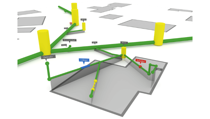
Background plans such as floor plans and aerial images provide optimal orientation within the property. With the site plan module LP2000, georeferenced work can be performed and objects to be investigated can be extracted from the background plan. The entire sewer network is displayed graphically in 3D, simplifying access to inspection data. Depending on requirements, labels such as pipe number, connection point, pipe length, dimension or material can be displayed.
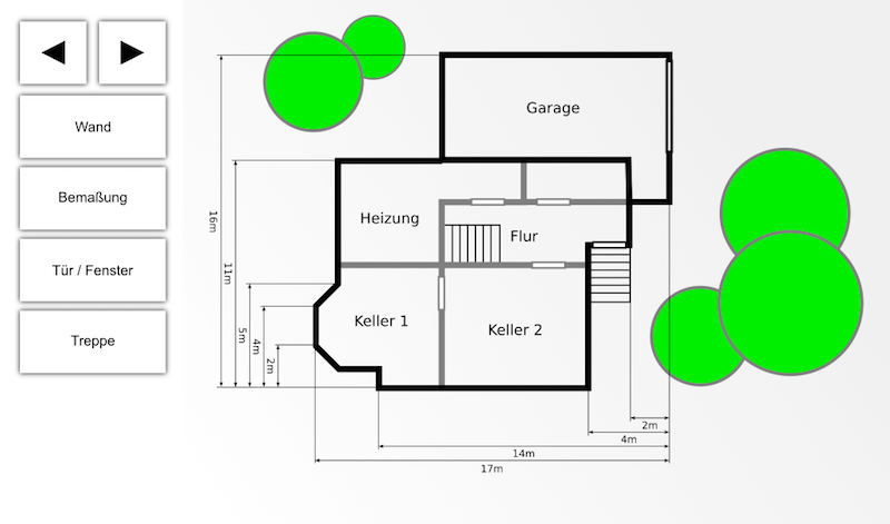
Floor Plan Editor
As an alternative to a site plan, a floor plan of the property can also be created and stored using the floor plan editor.
If a floor plan already exists (e.g., in the form of an architectural plan), it can be scanned and imported as an image into GS2000.
Position Measurement in the Site Plan
The accuracy of the pipe network is ensured through numerous correction and measurement options. Individual points or sections can be surveyed in the field. This allows, for example, access manholes to be transferred to the site plan with centimeter accuracy. The correction can be carried out on-site (during the inspection).
Automatic Route Measurement
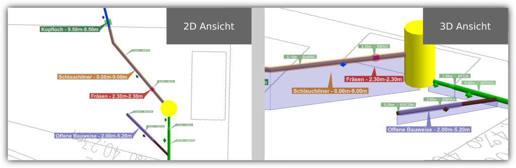
With the GS2000 software, the pipe routing (geometry data) of the sewers can be automatically recorded during the inspection. The routing can be viewed in 2D or 3D. The inspector can see at any time where they are currently positioned in the background plan. Additionally, existing geometry data can be imported at a later point. During re-inspection, the route does not need to be re-recorded, as bends and branches are automatically inserted. GS2000 also supports the import of data generated by measurement sensors.
Rehabilitation Planning
Through the integrated rehabilitation planning, any rehabilitation measures are displayed in the pipe network. Depending on requirements, these measures can be shown or hidden. GS2000: Rehabilitation Plan
Investigation of Lateral Connections
The inspection can start from both the main sewer and any other point within the property. This enables a comprehensive inspection of the entire pipe network.
Versatile Applications
There are two different applications for property inspection:
- GS2000 Compact as a standalone program, preferred for small systems » see inspection case
- GS2000 as a module in K2000
Benefits at a Glance
- Standards-compliant TV inspection
- Automatic recording of pipe routing in 3D
- Background plans (see LP2000)
- Recording of georeferenced geometry data
- Access to inspection data, images, videos and reports via 3D graphics
- Comprehensive measurement methods
- Inspection of pipes from both directions possible
- All common standards and interfaces are supported
- Rehabilitation planning
- Color-coded display of pipes according to action required
- License-free transfer of all data in 3D via the viewer program KS2000